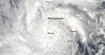
Using data collected by the Moderate Resolution Imaging Spectroradiometer (MODIS) instrument on the Aqua satellite, experts at NASA were able to compile a new image of the powerful Typhoon Haiyan, as it battered the central Philippines, between November 7-8.
According to local reports, the massive storm made landfall at 20:40 UTC on November 7, in the country's Samar Province, with sustained winds reaching as much as 300 kilometers (195 miles) per hour just prior to landfall. Much faster gusts were also detected.
MODIS captured this optical-wavelength image of Typhoon Haiyan on November 8, at around 5:10 UTC. At that time, the average speed of its winds was calculated at around 270 kilometers (165 miles) per hour, NASA experts say in a statement.
Aqua also observed the storm with its Atmospheric Infrared Sounder (AIRS) instrument. The Indian Space Research Organization's (ISRO) OceanSAT-2 spacecraft used its OSCAT radar scatterometer to gather additional data of the typhoon as well.

 14 DAY TRIAL //