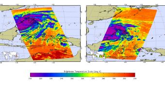
Scientists used two powerful satellites to capture two incredible views of one of the most dangerous and powerful storms ever to be observed on Earth. Typhoon Haiyan made landfall in the Philippines yesterday, November 8, battering the islands with heavy rains and winds.
Experts say that the massive storm came with winds traveling at an average speed of 314 kilometers (195 miles) per hour. Some gusts were recorded with top speeds of 379 kilometers (235 miles) per hour. Fortunately, these speeds decreased before the storm struck central Philippines.
According to scientists with the US Navy Joint Typhoon Warning Center, this was one of the most powerful storms ever recorded. By the time Typhoon Haiyan reached land, it boasted maximum sustained winds of up to 235 kilometers (147 miles) per hour.
Peak wind speeds over land were recorded at 275 kilometers (170 miles) per hour. Locally, this storm is known as Typhoon Yolanda. Scientists observed it using the NASA Aqua spacecraft and the OceanSAT-2 spacecraft, which is operated by the Indian Space Research Organization (ISRO).
The Aqua Atmospheric Infrared Sounder (AIRS) instrument captured two images, on November 7 and November 8, respectively, showing the storm and its structure in infrared wavelengths. The first photo was captured when Typhoon Haiyan was located 334 kilometers (214 miles) away from Manila.
The November 8 image reveals just how fast the storm moved west, centered on a course that will take it above Vietnam over the next couple of days. The temperatures inside the storm are color-coded, with purple showing the coldest cloud-top temperature and, by extension, the area of most intense rainfall.
An additional image was collected by the OSCAT radar scatterometer on the OceanSAT-2 spacecraft, showing Typhoon Haiyan on November 6. Scientists with the NASA Jet Propulsion Laboratory used advanced wind retrieval algorithms on this photo to calculate top wind speeds.
The group determined that the storm boasted speeds of up to 206 kilometers (128 miles) per hour, just two days before hitting the Philippines. The reason why these speeds are so small compared to the ones Aqua saw is that the study was conducted on a smaller area of the typhoon.

 14 DAY TRIAL //