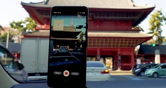
Google Street View is an amazing piece of technology that allows us to explore so many places around the world from the comfort of our own homes.
The street-level imagery is captured using advanced 360-degree cameras installed on Google Maps cars or even carried by staff in places where vehicles aren’t accessible, and previously, users were also allowed to contribute with their own content as long as they had the necessary hardware.
But Google is making the whole thing much easier thanks to an update to the Street View app, essentially allowing anyone with an Android phone to contribute to this service with their own photos.
In other words, you no longer need super-expensive cameras and other equipment, as an Android phone is pretty much enough to upload content on Street View.
“Before this feature, you would typically need special 360-degree cameras to capture and publish Street View imagery. Some equipment you could even attach to the roof of your car, but at the cost of thousands of dollars; that’s out of the realm for many. Now that anyone can create their own connected Street View photos, we can bring better maps to more people around the world, capturing places that aren’t on Google Maps or that have seen rapid change. All you need is a smartphone—no fancy equipment required,” Google explains.
Using this feature is as easy as it gets.
First and foremost, you need to update the Street View app to the latest version. You should then see a Create button on the bar at the bottom of the screen, and clicking it allows you to start recording a video that is then automatically uploaded to Google.
The Mountain View-based search giant takes care of everything, including the processing, the editing, and all the other necessary edits, so technically, your only job is to record the footage and that’s all.
“With our updated Street View app on Android, it’s now easier than ever to collect your own Street View imagery and put it in the right place on Google Maps. Using our new connected photos tool in the app, you can record a series of connected images as you move down a street or path,” Google explains.
“These images are captured using ARCore, the same augmented reality technology we use to produce experiences like Live View. After you record your images and publish them via the Street View app, we automatically rotate, position and create a series of connected photos. We then place those connected images in the right place on Google Maps, so your new Street View can be found in the exact location where it was taken for others to see and explore.”
What you need to do know is that the photos uploaded by users on Street View are displayed differently from the ones captured by Google’s advanced cameras. The user content appears on Street View with dotted blue lines, while the available Google Street View imagery is shown with a solid blue line.
Needless to say, Google allowing anyone to contribute to Street View will eventually help the company capture even more of the world and bring it at one-click distance. It will definitely take a while, but on the other hand, the company can thus reach places it wouldn’t otherwise be able to show on Street View for obvious reason.
Not to mention that the content displayed on Street View will be more accurate and up-to-date, simply because more people can contribute with their own images for the same place, so only the most recent version would be displayed for users across the world.

 14 DAY TRIAL //