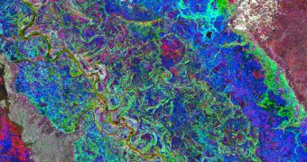
The psychedelic colors in the image above show the floodplains of the Zambezi River, one of the most important and historically-relevant water courses in Africa, and indeed the world. This photo is not in false color; all the data it contains were captured by an orbital radar instrument.
The Radar Altimeter 2 (RA2) dual-frequency radar instrument is installed aboard the European Space Agency's (ESA) Environmental Satellite (Envisat) spacecraft. The vehicle was launched into space on March 1, 2002, and became nonoperational a decade later, when mission controllers lost contact with it, on April 8, 2012.
On May 9, 2012, the satellite's mission was officially ended. However, in its 10 years of operations, Envisat was able to collect a wealth of data about our planet, including two images of the Zambezi floodplain. Three images were combined to create this view, collected on March 1, September 27 and December 26, 2011, respectively.
The RA2 instrument was used for these studies because radars can penetrate even the thickest cloud covers, meaning that they can perform measurements even during the night, and during storms.

 14 DAY TRIAL //