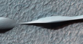
Using the High Resolution Imaging Science Experiment (HiRISE) instrument on the NASA Mars Reconnaissance Orbiter (MRO), researchers at the University of Arizona were recently able to capture an amazingly-detailed image of weird sand dunes in the Hellas impact basin.
Also known as Hellas Planitia, this basin is located on the southern hemisphere of the planet, and boasts a diameter of around 2,300 kilometers (1,400 miles) east to west. The entire landscape feature is around 7,152 meters (23,465 feet) deep, and features vast amounts of constantly-shifting dunes.
The particular type of dunes seen in this HiRISE image is called barchan, and they are slowly-creeping dunes, capable of taking on very bizarre appearances. In this case, barchan were formed as winds blew in a single direction, from east to west. Similar dunes can be found in deserts on Earth, too.
An interesting piece of trivia about this photo is that it was snapped on November 4, 2013, which is the exact same day when MRO exceeded its 200-terabit mark. This is how much data the orbiter has relayed back to Earth since arriving at Mars, back in 2006.

 14 DAY TRIAL //