While conducting statistical studies of temperatures at different locations around the world, experts discovered some time ago that certain regions are colder than their counterparts at the same latitude. A group of experts now believes it may have discovered the reason why.
Throughout the northeastern coast of the United States and the eastern coast of Canada, and the northeastern coast of Asia, temperature are on average around 10 degrees Fahrenheit lower than in places at the same latitudes.
For example, the average winter temperature recorded in New York City is 32 degrees Fahrenheit, whereas the city of Porto, in Portugal experiences an average temperature of 48 degrees Fahrenheit.
The two cities are located on the same latitude line. The situation repeats itself in the case of cities in the aforementioned areas, which are all colder than their counterparts on the same latitude line.
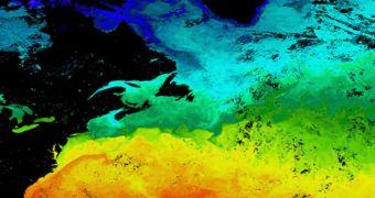
In a new study, scientists with the California Institute of Technology (Caltech), in Pasadena, may have discovered the reason why this happens. They say that the eastern coasts of both North America and Asia are surrounded by warm waters.
“These warm ocean waters off the eastern coast actually make it cold in winter – it's counterintuitive,” explains the Caltech Frank J. Gilloon professor of environmental science and engineering, Tapio Schneider. He led the work with postdoctoral fellow Yohai Kaspi.
The team published the conclusions of its research in a paper appearing in the March 31 issue of the top scientific journal Nature. The work also includes the mechanism that scientists believe is responsible for this state of affairs.
Computer simulations have revealed that the warmer waters are on a continent's eastern seaboard, the more likely they are to release a lot of heat in the air, in the form of atmospheric waves.
These waves then go on to attract cold air from the polar regions. After that, the cold air forms a plume a little to the west of the shoreline. In the case of North America, this means it affects the eastern US and eastern Canada.
“It's not that the warm Gulf Stream waters substantially heat up Europe. But the existence of the Gulf Stream near the U.S. coast is causing the cooling of the northeastern United States,” Kaspi reveals.
In future studies, the Caltech investigators want to collect even more data about these phenomena, by incorporating additional data in their computer models. These may also include feedbacks that continents and cloud covers generate.
The new study was conducted with funds from the Climate and Global Change Postdoctoral Fellowship, which is provided by the National Oceanic and Atmospheric Administration (NOAA). Funds from a David and Lucille Packard Fellowship and the National Science Foundation were also used.

 14 DAY TRIAL //