14 DAY TRIAL //
 Google Maps for mobile, a service / application that already enjoys a number of over 100 million users all around the world, has been recently updated for devices running under Google's own mobile operating system, Android, to Google Maps 5.0.
Along with the change of version, the new flavor brought in some very appealing features, aimed mainly at handsets that run under Android 2.0+, though not all devices would offer support for them: 3D mode, Offline reliability, and Offline rerouting.
Overall, these features would offer a better experience to all users, provided that their devices offer support for them, while also showing that navigation on mobile devices could be more than what we might have expected it to be.
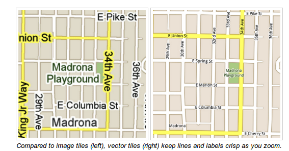
Unlike the previous version of the application, the new Maps comes with vector graphics, which replaces the previous image-based drawing of the map, while also enabling users to interact in new ways with the solution.
The list would include:
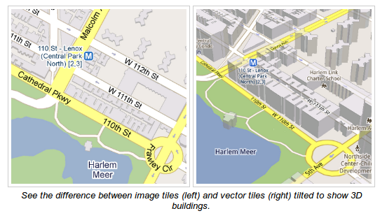
- Tilting: Drag down with two fingers to tilt the map. Tilt while zoomed in on one of the 100+ cities around the world with 3D buildings to see a skyline spring to life.
- Rotating: Twist with two fingers to rotate the map. After tilting to see 3D buildings, rotate around them to gain a new perspective from any direction.
- Smooth zooming: Slide two fingers together or apart, and see the map and labels continuously scale to any zoom level, stopping when your fingers stop.
- Compass mode: Center the map on your location, and then tap the compass button in the top right corner. The map will flip into 3D mode and start rotating to match your perspective, while still keeping all the labels upright and readable.
The vector graphics at the base of the new Maps are meant to “describe the underlying geometry of the map,” and do not include the map itself, which translates in less data being downloaded on handsets.
According to Google, “a combination of modern device hardware and innovative engineering allow us to stream vector tiles efficiently and render them smoothly, while maintaining the speed and readability we require in Google Maps.”
The use of vector graphics in Google Maps 5.0 for Android results in the possibility to draw the same map from different perspectives based on the same set of data.
This means that zooming would be much better that before, not to mention that it won't require the download of a new set of images each time one would like to zoom to a new level.
“One vector tile has the underlying vector data (or blueprints) to draw the map at many different levels of scale. So when you zoom, the map stops when your fingers stop, and roads and labels always stay crisp,” Google notes.
Moreover, the inclusion of vector graphics in this application results in the possibility to include new levels of detail that what was possible with the previous 2D images, thus the presence of 3D building data for over 100 cities around the world.
In Google Maps 5.0 for Android, “each building is drawn in 3D using a polygonal building footprint and heights for different parts of the building. And with tilt and rotate, you can see them from a variety of different angles.”
Those Android phone users out there interested in the new Google Maps 5.0 for Android would find the application available for download from the Android Market. The software solution is compatible with handsets based on Android 1.6 or higher but, as stated above, the new features would work only on Android 2.0+ devices.