The spring flooding season has already began in parts of the United States, specialists say, but has not yet manifested itself entirely. Forecasters with specialized agencies announce that the worst has yet to come. When it does, people need to be ready.
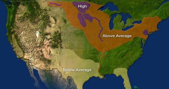
Over the next few weeks, about half the country will be subjected to a higher-than-normal risk of being hit by floods, say investigators with the US National Oceanic and Atmospheric Administration (NOAA).
Areas affected span from the north-central regions to the northeast and the Midwest. Experts revealed the risk pattern in a new outlook released by the NOAA National Weather Service (NWS).
The organization is already collaborating with the Federal Emergency Management Agency (FEMA) in making the population aware of the impeding floods. These actions are carried out as part of the national Flood Safety Awareness Day.
Eastern North Dakota, northwest Minnesota, eastern Montana, South Dakota, lower New York, eastern Pennsylvania, northern New Jersey and a host of other regions are targeted by the NWS warning.
“For the third consecutive year, the stage is set for potential widespread, record flooding in the North Central United States,” says the NOAA NES director, Jack Hayes, PhD.
“We’ve been coordinating with federal and state partners and high risk communities since December to raise awareness and help them prepare. All the ingredients are in place for major flooding so this situation should be taken very seriously,” the official goes on to say.
“We’re asking citizens to stay informed and be prepared,” Hayes explains. Part of the reason why floods are expected is because the warm temperatures that swept the US recently are causing a snowpack meltdown on numerous mountains.
Over the next 14 days or so, a relatively large number of storm systems will also appear above these areas, increasing the risk of flooding even further. Generally, the combination of meltwater and rainwater causes substantial runoff, that may breach levees and other defense mechanisms.
According to simulations conducted at the National Weather Service based on readings of temperature and precipitation levels that affected the area during this fall and winter, it would appear that the north-central US contains a water-rich snowpack.
Experts say that the amount of water that the ices will release as temperatures increase will be among the largest in the past 60 years. The NWS outlook is part of an ongoing effort the agency makes to reduce the number of people that fall victim to floods.
On average, floods claim the lives of some 100 people each year. Most deaths take place in cars, and are entirely preventable, the investigators say.

 14 DAY TRIAL //