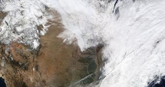
Officials with the American space agency have just released a new image showcasing the magnitude of the current snowstorm affecting the United States. The storm is caused by the shift of the polar vortex from over the Arctic to the central and eastern regions of the US and Canada.
Both countries are currently facing record-low temperatures, which are unlikely to abate soon. The US Midwest and East Coast are especially affected, with temperatures lower than any recorded over the past 120 years or so. At the same time, people on the other side of the planet, in Australia, are getting backed in record-high temperatures.
The image attached to this article was created from several photographs collected by the NASA Aqua satellites, during a series of passes it made over the United States on January 2, 2014. The NOAA GOES-13 satellite also snapped some images of its own during the same interval.
The snowstorm was recorded by the Moderate Resolution Imaging Spectroradiometer (MODIS) instrument on the Aqua satellite. The dataset shows how the US West Coast is spared by the cold front, while the western parts of Canada are not. The central regions of the US are also snow-free, though temperatures are very low.

 14 DAY TRIAL //