Scientific studies seeking to determine which areas of the United States are the most prone to experiencing earthquakes have shown that the West Coast is at the highest risk. But the East Coast may be threatened as well, and so experts are expanding a critical sensors network east of the Mississippi.
In western states such as California and Washington, things are pretty clear cut. The San Andreas fault line is generating tremors almost constantly, and can from time to time trigger devastating earthquakes.
There are some fault lines in the Midwest as well, that may rupture at one point or another. But studies have recently revealed that the East Coast is not entirely out of the woods. Experts decided to expand the seismic network as a precautionary measure.
The EarthScope Transportable Array seismic network first started off near the Pacific Ocean, as a means of keeping track on seismic events here. Over the past six years or so, it has been expanding constantly eastwards.
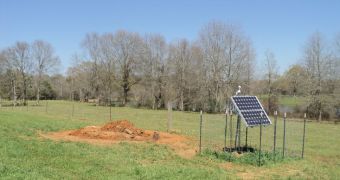
Recently, an important milestone was reached when the first of its sensors was installed eastwards of the Mississippi River. The sensor is located on a private farm, about 5 miles northwest of Columbia, Miss.. The location is called Station 345A.
For the next 24 months or so, the sensor will continuously record ground motions produced by local, regional and global earthquakes, say experts with the US National Science Foundation. The NSF is funding the EarthScope project.
NASA and the US Geological Survey (USGS) are also contributing to this endeavor. The array itself is managed and maintained by the Incorporated Research Institutions for Seismology (IRIS).
“Research using data from the Transportable Array has already improved our understanding of the structure and dynamics of the western United States, “NSF program director for EarthScope Greg Anderson explains.
“With the arrival of the Transportable Array in the eastern United States, scientists will derive new insights about the older core of our continent and processes related to the formation and modification of continents over geologic time,” the official explains.
At this point, EarthScope's array features some 400 state-of-the-art seismic stations, which are spread about 70 kilometers away from each other. This ensures a high degree of consistency in the data they collect and process.
Thus far, these stations have produced around 22 terabytes of data. The information has been made available to Earth scientists, geologists and anyone else who is interested in them.

 14 DAY TRIAL //