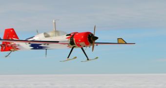
Scientists with the Center for Remote Sensing of Ice Sheets (CReSIS) at the University of Kansas have recently demonstrated a new set of capabilities during a study of Antarctic ice sheets and topography. The team was able to successfully use a small and lightweight Unmanned Aircraft System (UAS) to map ice thickness and the topography of the underlying terrain, marking a world first in this area.
The reason why this study is so important is because using radars to study ice sheets has until now been reserved for very expensive scientific expeditions, since it implied the need for an advanced logistics and support system. Additionally, flying larger, manned aircraft outfitted with radar instruments entails a higher degree of risk that sometimes cannot be justified through the scientific return alone.
By replacing these airplanes with smaller UAS, scientists can now have access to an inexpensive platform for conducting studies over some of the world's most inhospitable – and environmentally-important – areas. Determining how Antarctic ices change over time is extremely important for predicting the effects of global warming and climate change.
The CReSIS team published details about its new study in the March/ April issue of the esteemed scientific journal IEEE Geoscience and Remote Sensing Magazine. The investigation was supported by the US National Science Foundation's (NSF) Division of Polar Programs and the State of Kansas. The UAS platform was tested over a site on the West Antarctic Ice Sheet (WAIS).
“We're excited by the performance we saw from our radar and UAS during the field campaign. The results of this effort are significant, in that the miniaturized radar integrated into a UAS promises to make this technology more broadly accessible to the research community,” explains Rick Hale.
The expert, who holds an appointment as an associate professor of aerospace engineering at the University of Kansas, is also the associate director of technology at CReSIS. He explains that UAS-mounted radars could soon be used at a large scale, for studying Antarctica, the Arctic, and the all-important land-based glaciers of Greenland.
The University of Kansas team says that the UAS it used in Antarctica has a liftoff weight of just 38.5 kilograms (85 pounds), all instruments and fuel included. The agile aircraft boasts a range of about 100 kilometers (62 miles), meaning it can map a relatively large swath of land before it has to return for refueling. The airplane lands on sleighs instead of wheels.
Antarctic is, and will remain, the target of numerous studies, largely due to the fact that it holds enough ice to raise global sea levels by around 66 meters (216 feet) if it melted. Greenland also contains a vast amount of ice, but not nearly as much as the Southern Continent.

 14 DAY TRIAL //