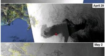
Almost two weeks ago, on April 20, an explosion and subsequent fire completely destroyed the Deepwater Horizon off-shore drilling rig. The explosion enabled crude oil to spill from the newly drilled well into the Gulf of Mexico. The disaster is being labeled as the worse oil-spill accident in US history and authorities are still struggling to contain it, with little success.
Google has put together several sources of info on the expanding spill, using data from NASA, ESA and others. The imagery and information are being made available in Google Earth and also at a dedicated web page Google has set up.
“Two weeks ago, there was a fatal explosion on the offshore oil rig Deepwater Horizon in the Gulf of Mexico. The rig sank shortly afterwards, and since then the well has been leaking crude oil into the Gulf, spreading an oil slick towards the U.S. Gulf Coast,” Christiaan Adams from the Google Crisis Response team wrote.
“This spill is pouring as many as 5,000 barrels (210,000 gallons) of oil a day into the Gulf and poses a serious threat to coastal industries, sensitive habitats and wildlife, including numerous species along the coastal areas of Louisiana, Mississippi, Alabama and Florida,” he explained.
The first images became available last week from NASA’s MODIS Rapid Response System, which was developed to provide satellite images of the Earth's landmasses in near real time. It is currently tracking the Deepwater Horizon disaster and is providing updated imagery of the spill. You can check out the satellite images in Google Earth by downloading this KML file. More recent images from the European Space Agency’s ENVISAT radar satellite are also available for download here.
The site of the disaster is highlighted in Google Earth if the Places of Interest layer is active. The site, marked by a red icon in the Gulf of Mexico, contains some information on the disaster and links to more data and imagery. You can also check out all the aggregated data on this Google website.

 14 DAY TRIAL //