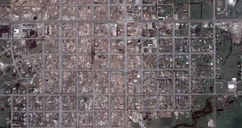
As Greensburg, Kansas was recently affected by a devastating tornado, Google Earth was quickly updated to display relevant pictures with the damaged areas. The photos were offered by Google's satellite provider DigitalGlobe that managed to capture impressive imagery with the zone. The updates are all included in a separate Google Earth database that can be downloaded using this link and which is compatible using the Open File function from the application.
"Recently the town of Greensburg, Kansas was devastated by an F5 tornado and most of the town was destroyed. On May 7th one of our satellite providers, DigitalGlobe, jumped into action and gathered imagery of the region for search-and-rescue teams. Today we are making this before-and-after imagery available as a Google Earth overlay. We think you'll agree that the imagery is quite powerful, and we hope it is a valuable resource for rescue teams, residents, and all of those touched by this natural disaster," Brian McClendon, Engineering Director, sustained today.
Some time ago, Google was involved in a similar problem concerning a hurricane because it displayed detailed pictures with Katrina. As you might know, the search giant published the photos just after the hurricane assaulted the city. The official reason for the availability of the pictures was that Google wants to help the authorities find affected victims and damaged buildings of New Orleans.
Recently, the local authorities accused Google of censoring the truth as all the images with the hurricane were replaced with older pictures. Because the search giant wanted to offer the users the chance to view all the photos with hurricane Katrina, Google released a separate file that contains the imagery.

 14 DAY TRIAL //