 14 DAY TRIAL //
 An unexpected radio reflection from the surface of Titan has allowed ESA scientists to deduce the average size of stones and pebbles close to the Huygens' landing site. The technique could be used on other lander missions to analyze planetary surfaces for free.
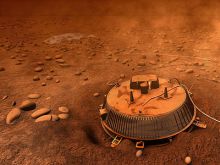
When Huygens came to rest on the surface of Titan on 14 January 2005, it survived the impact and continued to transmit to the Cassini mothership, orbiting above. Part of that radio signal 'leaked' downwards and hit the surface of Titan before being reflected back up to Cassini. On its way up, it interfered with the direct beam.
As Miguel P?rez-Ay■car, a member of the Huygens Team at ESA's European Space Research and Technology Centre (ESTEC) in The Netherlands, and his colleagues watched the signal coming back, they were initially puzzled to see the power of the signal rising and falling in a repetitive manner.
"Huygens had not been designed to necessarily survive impact so we had never thought about what the signal would look like from the surface," says P?rez. After making a joke that aliens must be dragging the craft along the surface, P?rez and the team began work at once to understand the signal.
The clue was the repetitive oscillation of the power. It made P?rez think about the interaction of the direct signal with that reflecting from the surface of Titan. As Cassini traveled away from the Huygens landing site, the angle between it and Huygens changed. This altered the way in which the interference between the reflected and direct beams was detected, perhaps causing the variation in power.
He began running computer models and saw that not only could he reproduce the received signal but also it was sensitive to the size of pebbles on the surface of Titan.
Cassini collected data for 71 minutes after Huygens landed. After that time, the spacecraft's motion took it below the horizon as seen from Huygens' landing site. Until then, it soaked up radio signals that encoded information about a swathe of Titan's surface from 1 meter to 2 kilometers to the west of the landed probe.
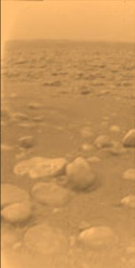
To accurately mirror the true signal, P?rez and his team discovered that the surface swathe must be relatively flat and covered mostly in stones of around 5-10 centimeters in diameter.
This unique result complements the data taken by the Descent Imager and Spectral Radiometer (DISR) instrument. When Huygens came to rest on the surface of Titan, DISR was pointing due south. Its images show stones and terrain in good agreement with the newly deduced western facing radio data. "This is a real bonus to the mission. It requires no special equipment, just the usual communications subsystem," says P?rez.
Now that the scientists have understood the process using the unexpected Huygens data, the technique could be implemented on future lander missions. "This experience can be inherited by any future lander," says P?rez, "All that will be needed is a few refinements and it will become a powerful technique."
By subtly altering the properties of the radio beam for instance, the radio transmitter and receiver can be optimized to help deduce the chemical composition of the planetary surface.
Credits: ESA/NASA/JPL/University of Arizona