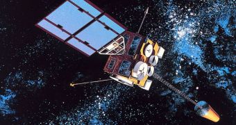
Hundreds of websites, mobile phone applications, computer widgets and other electronic means can today be used to gain non-stop access to weather information. Some software even allow for real-time updates. Hurricanes, cyclones, tropical storms, dangerous cloud formations, soil moisture and salinity, as well as a range of other data on Earth's climate can today be quantized, and placed in statistical charts. This in turn allows for accurate predictions on their evolution. But none of these abilities we currently have would be possible without the use of weather satellites, Space reports.
The first such instrument was called TIROS-1 (Television Infrared Observation Satellite), and it was launched on April 1, 1960, from Cape Canaveral, Florida. Though the first image it sent back was all fuzzy, it was the instrument largely responsible for changing the way governments approached weather observations and planetary studies. It is safe to say that the small spacecraft was the mission that proved the worth of space satellites in a time when their value was still unproven. Today, we take satellites for granted, but 50 years ago they were very expensive to launch and operate.
“TIROS-1 started the satellite observations and inter-agency collaborations that produced vast improvements in weather forecasts, which have strengthened the nation. It also laid the foundation for our current global view of Earth that underlies all of climate research and the field of Earth system science,” NASA Administrator Charles Bolden said recently. “This satellite forever changed weather forecasting. Since TIROS-1, meteorologists have far greater information about severe weather and can issue more accurate forecasts and warnings that save lives and protect property,” added the US National Oceanic and Atmospheric Administration (NOAA) administrator, Jane Lubchenco.
By 1975, the ten TIROS series satellites launched by NASA were joined by the first Geostationary Operational Environmental Satellite (GOES) mission. Unlike its predecessors, which surveyed the planet from a polar orbit, the GOES spacecraft looked at the same area from the vantage point of a geostationary orbit. Combining the two datasets allowed weather forecasters to obtain amazingly-detailed information about global weather patterns and the influences they exerted on each other.
“We could not provide skillful hurricane forecasts without the crucial imagery and data from geostationary and polar-orbiting satellites. Before satellites, tropical storms and hurricanes were often missed if they stayed out over the open ocean. Now we know tropical storms and hurricanes have swings in numbers from decade to decade,” explained expert Chris Landsea, who is the science operations officer at the Miami, Florida-based NOAA National Hurricane Center.
“NOAA Chief Economist Rodney Weiher estimated that the economic benefits of providing reliable warnings of geomagnetic storms to the electric power industry alone would be approximately $450 million over three years. Note that this doesn't include any other impacted industries, nor does it include the potential catastrophic impacts of a widespread blackout due to a geomagnetic storm,” said NOAA Space Weather Prediction Center expert Bill Murtagh. Solar flares can easily disrupt power grids, fry transformers, and cause global blackouts.

 14 DAY TRIAL //