14 DAY TRIAL //
 If you thought the Google Street View trike was weird, get a load of this, the official Street View snowmobile. Google wanted to take some shots of the locations of the events in the Vancouver Winter Olympics. Cars don't really do that well on ski slopes and, somehow, pedaling the trike, which Google normally uses in remote locations, through the snow didn't really sound like a great idea. So the engineers came up with a way of jamming all the Street View camera equipment on the back of a snowmobile, no small feat in itself, the trike alone weighs in at around 200 - 250 pounds (100 - 125 kg), and sent the contraption up the mountains.
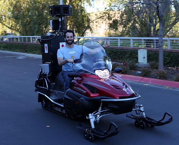
"Yes, you are indeed looking at a snowmobile equipped with our full Street View camera system. In typical scrappy Google fashion, we were able to put this together over the course of a few weekends using extra pieces for our Street View cars, some 2x4s, some duct tape, and a lot of extra hard drives (keeping them running properly in the freezing conditions was one of our major concerns)," Dan Ratner, senior mechanical engineer at Street View, wrote.
The Street View snow mobile is the brain child of Dan Ratner, that's him showing off in the pic on the left, the same engineer who built the Street View trike. The Google team hit the slopes with the snowmobile contraption to get the imagery, something that sounds a lot more exciting than it really was, as precision and steady driving are what make for good Street View photos. You can check out the results on Google Maps now and also on the dedicated site highlighting the locations.
Google has been covering the 2010 Winter Olympics pretty well, at least when it comes to its mapping products. All nine competition venues are modeled in 3D and available in Google Earth, something the company put quite a bit of effort into, employing photographers to get high resolution photos and getting a hold of aerial imagery of the venues. The resulting models are some of the most detailed in Google Earth even featuring the trees and the bleachers at the locations.