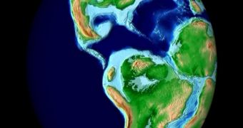
Since the 19th century, scientists noticed that similar fossils were found in nowadays continents located far away one from another. At the beginning of the 20th century, the American geologists suggested that continents could come off one from another. In 1915, the German scientist Alfred Wegener, in his work "The Origin of the Continents and the Oceans", showed that once Greenland must have been located on the Equator and large areas of South America and Africa, on the place where Antarctica is located now. Thus, the continents have moved away.
His theory of the continental translation was generally accepted until the '60s. Meanwhile, new gathered probes revealed a new real phenomenon: the plate tectonics. This theory says the continents are found in a continuous movement, with a speed of 1-10 cm (0.4-4 in) per year.
The movement of the continents was first suggested by the similitudes of South and North American continental shores to the European and African ones. The real borders of the continents are not the shores, but a shallow region called continental platform that makes the edge of the continents. After this platform, the continental embankment follows, when the depth descends steeply to the bottom of the oceans. If we draw the platforms' limits, we see that the contours of the continents match even more.
Geological studies further confirmed the translation theory. Wegener had discovered glaciation remains in South America, Africa, Australia and India. That ancient Ice Age occurred during the late Carboniferous and early Permian, about 300 million years ago, showing that, around that time, these land masses were united.
Identical 550 million year old rocks were found near Accra (Ghana) and Sao Paolo (Brazil). This similarity causes the prospectors to look for resources on the other part of the Atlantic when a layer is found on the coast of western central Africa.
Paleomagnetism (ancient magnetism) also proves the plate tectonics. When molten rocks from lava solidify, those containing iron get magnetized. In this moment, they get the orientation of Earth's local magnetic field and indicate the disposition of the Earth's magnetic field in ancient times.
Fossil ferns from South America, South Africa, Madagascar, India and Australia were strikingly similar. Fossil reefs were found in North America, Europe, North Africa and Middle East, areas where today they could not form. Lystrosaurus, a type of mammalian-reptile (a group from which mammals evolved) which lived 250 million years ago, was found in Africa, India and Antarctica; this shows these continents once were united. Mesosaurus, a freshwater reptile 270 million years old was found in Africa and Brazil; it clearly could not swim to cross the Atlantic.
The rocks collected from the bottom of the oceans are no older than 200 million years, while the oldest rocks on the ground are 3.8 billion years old. This proves that oceans are relatively new. The topology of the ocean bottom revealed the existence of undersea mountain chains, called oceanic crusts. They are a hotbed of earthquakes and volcanism. The youngest rocks on Earth are found here, and new ones are generated through the obliteration of the tectonic plates. The age of the rocks increases as we come off the oceanic crust.
It seems that, 400 million years ago, there were 4 continents: North America, Europe, Angara (Asia) and the southern Gondwana (made of South America, Africa, Australia, Antarctica and India). In time, North America and Europe collided, forming the Appalachian Mountains and the Eastern Greenland mountains; also those from western Ireland, Scotland and Scandinavia.
275 million years ago, Euramerica (North America plus Europe) collided to Angara, forming the Urals Mountains and a new giant continent, Laurasia. Laurasia was separated from Gondwana through the Sea of Thethys (today's Mediterranean is a remain of Thethys), but later they joined into a sole supercontinent, called Pangaea. One sole ocean was found, named Pahthalassa.
180 million years ago, Pangaea started to break up and, through the tectonic movements, continents gradually reached their current location. Even today, as said, they are still moving, at a speed of 2-12 cm (0.8-4.8 in) per year.

 14 DAY TRIAL //