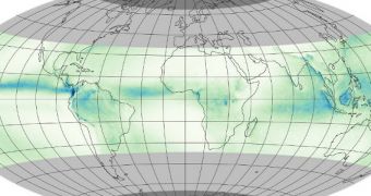
The image above shows the average rate of daily rainfall recorded at mid-latitudes on our planet between 1998 and 2011. This impressive dataset was put together from key measurements conducted by an innovative satellite, the Tropical Rainfall Measuring Mission (TRMM), which was developed by NASA and the Japan Aerospace Exploration Agency (JAXA).
Launched in 1997, the TRMM was the first mission of its type, destined specifically to measure tropical rainfall in relation to Earth's water and energy cycles. Its orbital path only allows the spacecraft to take these measurements between 35 degrees latitude north and 35 degrees latitude south. The most important instruments on board are a precipitation radar and a microwave imager.
Over nearly two decades of work, the orbital asset was able to collect an impressive volume of data on our planet's hydrological cycle and managed to keep a close eye on moderate to intense tropical rainfalls occurring within its field of view. TRMM studies enabled experts to investigate new atmospheric circulation patterns that would have otherwise remained undetected.
On February 27, 2014, TRMM got a new companion, its successor, the NASA/JAXA Global Precipitation Measurement (GPM) Core Observatory. This satellite will continue its predecessor's studies, but it will also extend its reach to the areas marked in light gray in the image above. These two satellites will probably continue to work together until the older spacecraft is unable to continue.

 14 DAY TRIAL //