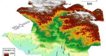
While conducting investigations into the sediment layers on the floor of the North Atlantic Ocean, a team of geologists identified a submerged landscape that hints at the lost city of Atlantis.
As evidenced by the attached image, this portion of the ocean floor looks as if it once was a plain above the waves. It features a central channel that looks as if it was cut by a river, as well as peaks that may have been mountains many years ago.
During the new investigation – which was conducted in order to gather data for oil companies – experts determined that this landscape is about 56 million years old. The entire area is submerged beneath 2 kilometer (1.2 miles) of Atlantic water.
The senior researcher on the new investigation, expert Nicky White, say that the landscape “looks for all the world like a map of a bit of a country onshore,” an ancient, fossilized sight that was preserved excellently beneath the waves.
According to the research team, the datasets that were collected during this investigation reveal the existence of a large area underneath the north Atlantic, that stands out from the surrounding ocean floor. The area may have once existed above the waves.
Geologists believe that this region may have once connected the area that is now called Scotland with Norway, hundreds of millions of years ago. Most likely, this 3,861-square-mile (10,000-square-kilometer) landscape was only visible when the world was very warm.
In a paper published in the July 10 issue of the top journal Nature Geoscience, experts explained that they've used an advanced echo-sounding technique to image the ocean floor. This method is extremely precise, and able to produce 3D images of its targets.
White, who holds an appointment as a geologist at the University of Cambridge, in the United Kingdom, says that the recent survey revealed the existence of eight major rivers, that once criss-crossed their way across the fertile landscape.
Geological evidence also indicate that the area formed above the water, and then got submerged as the planet cooled, and ocean levels rose. According to expert, the area only existed as dry land for as few as 2.5 million years, LiveScience reports.

 14 DAY TRIAL //