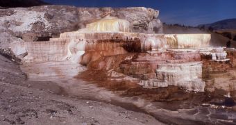
The fact that a host of companies are interested in geothermal development just outside the borders of the Yellowstone National Park is no longer a secret, but experts now need to figure out how to do this without upsetting this unique habitat. Recently, experts created a map of its underground heat.
One of the hallmarks this natural reserve retains is that it contains literally thousands of mud pots, terraces and geysers, in addition to hot springs and other similar landscape features. Old Faithful is just one of them, and they all need to be safeguarded.
The reason why there is still such a high level of geothermal activity being displayed at Yellowstone is that the entire reserve sits in the caldera of a still-active supervolcano, one of the very few such structures that ever existed.
If this volcano were to erupt, it would cover the United States in more than a foot of ash in just a few days, and would then mostly likely bring about a small ice age for the entire planet. Needless to say, its geothermal potential is huge.
As such, developers have been showing their interest in constructing various installations to take advantage of this potential. However, the National Park Service (NPS) has been tasked with making sure that such exploitations would not remove too much energy from the geysers and hot springs.
“If that geothermal development outside of the park begins, we need to know whether that's going to cause Old Faithful to suddenly stop spewing,” Montana State University expert Rick Lawrence says.
The investigator received funds from the Yellowstone Park and the NPS to conduct a study with his colleague, Shannon Savage, on the way in which geothermal energy moves about below the surface.
Full details of their conclusions will be presented on Friday, December 9, at the fall meeting of the American Geophysical Union (AGU), which is currently being held in San Francisco, California.
The team did reveal that it used visible light and heat-sensitive data channels on the NASA/USGS Landsat satellite to conduct its investigations. At the same time, the study is a part of a larger project started in 2005, and focused on monitoring several key aspects of the park and its supervolcano.
One of the main objectives in the study is to determine which areas of the park – if any – are connected by the same underground plumbing. This can be established by checking how temperatures fluctuate in various regions over decades.
Landsat data are very useful in this regard, since they span back all the way to 1984. By continuing to monitor the park, experts could soon decipher the mysteries that give Yellowstone Park its unique appeal.

 14 DAY TRIAL //