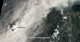
A new photo snapped by the Advanced Land Imager (ALI) instrument on the NASA Earth Observing-1 (EO-1) satellite reveals a massive plume of ash covering the landscape around the Sinabung volcano, in Indonesia. This mountain is famous for erupting 50 times in a single night, on January 4, 2014.
The last times the volcano erupted was on August 29, 2010, and in September and November 2013. Before 2010, the mountain had remained quiet for more than 400 years, locals say. Geologists say that the volcano is roughly 12,000 years old.
EO-1 collected the photo above on January 16, 2014, nearly two weeks after eruptions started again. Data from the satellite reveal the presence of pyroclastic flows spreading at least 4.5 kilometers (2.8 miles) down the slopes of the large volcano. This led authorities to evacuate thousands of nearby villagers.
Coffee and chilli pepper plantations around the volcanoes are already blanketed in dust and ash, giving rise to question about the economic future of an already-impoverished area. Satellites from several space agencies continue to track the volcano's eruptions and behavior. Sinabung lies 40 kilometers (25 miles) away from the famous Lake Toba supervolcano.

 14 DAY TRIAL //