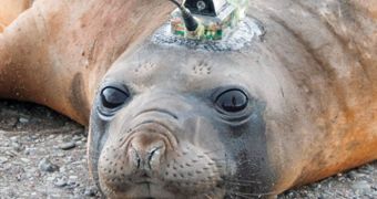
A team of oceanographers has employed a less-usual method of surveying the sea floor, when they attached sensors to the heads of seals. This led to discoveries that would have been difficult to make otherwise.
The investigators, who are conducting their research in Antarctica, explain that gluing sensors to the heads of seals is proving to be extremely useful, given that the animals get around a lot.
This approach has the added benefits of helping keep track of the way the sea population uses its natural habitat as well, the researchers say.
As opposed to renting a ship capable of mapping the sea floor, experts say that using the seals is inexpensive, and also highly-efficient.
Already, they have discovered a series of underwater channels, that were previously unknown. It could be that these sea floor features carry warm water around, directing it straight into the fragile ice sheets.
This approach “gives you a much denser picture of what the water depth is than anything you can conceivably do with ship tracks,” explains scientist Laurence Padman.
He is an oceanographer with Earth & Space Research, in Corvallis, Oregon, and also a coauthor of the new study. Details will appear in an upcoming issue of the journal Geophysical Research Letters.
The research group, led by University of California in Santa Cruz (UCSC) marine biologist Daniel Costa, tagged about 57 elephant seals, over a period of five years, Wired reports.
Scientists set up shop at the US Antarctic Marine Living Resources camp, in the South Shetland Islands. They say that seals have been used before, for example to measure water temperatures.
Walruses, whales and a number of other large marine creatures were also used by researchers in the past, but this is the first time the sensors are used to collect data of the crust below.
“You can actually map the ocean floor,” Daniel Costa says. This is done by collecting data from each sensor once every few second, during many diving sessions.
The database that the research team compiled features a total of about 200,000 dives for the study period. By combining the data, researchers got a clear picture of the ocean floor.
“It’s a novel and useful technique for gathering bathymetry data,” says British Antarctic Survey (BAS) ocean modeler Paul Holland, who was not a part of the investigation.
“We want to encourage other people who work with seal data to look into it. We just thought it was really cool,” Padman adds, again mentioning the low costs associated with this type of study.
Operating research vessels in the Antarctic can cost tens of thousands of dollars per day, he concludes.

 14 DAY TRIAL //