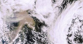
Southern Iceland is again being shaken by a violent volcanic eruption, which originates from the Grímsvötn volcano. Its caldera is spewing massive amounts of ashes and fumes high in the atmosphere, and the European Space Agency (ESA) is focusing its best satellites on the event.
One of the most important things that advisory centers across the Old Continent need to do now is assess the risk that the new eruption poses to aviation. But this cannot be done accurately without a little help from dedicated, Earth-monitoring satellites high above the planet's surface.
Grímsvötn has been dormant since 2004, but it started erupting again in the evening of May 21, forcing authorities in Iceland to close the national airspace in response. The situation is reminiscent of a similar event that took place last year, when the Eyjafjallajoekull eruption paralyzed air traffic worldwide.
In 2010, the measures Europe had to take were drastic. Hundreds of flights remained grounded, as fears about the ash cloud and its interactions with jet engines were high. Subsequent studies demonstrated that authorities were right to bar all flights.
The disastrous economic results of this shutdown are still vivid in the memories of authorities, businesses and people alike, and so everyone is monitoring the new situation with anxiety.
In order to respond to this demand for accurate data, the European Space Agency is using its best available resources, and collaborating with NASA on monitoring the new volcanic eruption.
Data collected by ground-based stations thus far show the ash plume moving towards northern Scandinavia, at a height of between 12 and 17 kilometers. This is a lot higher than the altitude at which last year's ash plume travekled.
“It was initially an ash-rich eruption that was also very wet. A large amount of ash has fallen out, mostly in the proximity of Iceland,” explains the leader of the ESA Support to Aviation for Volcanic Ash Avoidance project, Fred Prata.
“The volcano has also emitted a lot of sulfur dioxide that has been spreading north and northeast. Because this has been a high eruption there is less likelihood that it will affect continental and European aviation,” he goes on to say.
“Things could change if there is more volcanic activity – so it is important to monitor the ongoing eruption,” adds the expert, who is based at the Norwegian Institute for Air Research.
The polar-orbiting MetOp weather satellite ESA operates high above Earth was the first to image the disaster, using its Infrared Atmospheric Sounding Interferometer (IASI).
Europe's Meteosat Second Generation satellites and the US Geostationary Operational Environmental Satellites (GOES) network are also providing updates every 15 minutes.

 14 DAY TRIAL //