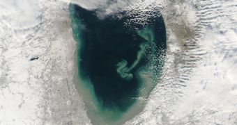
A new series of images snapped using the Aqua satellite reveals the extent at which sediments are being deposited into Lake Michigan, one of the five Great Lakes located at the border between Canada and the United States.
The Moderate Resolution Imaging Spectroradiometer (MODIS) instrument on the NASA spacecraft were able to pick up the massive amounts of suspended sediments with great clarity and detail.
Photos took in mid-December 2010 showed the southern end of the lake looking rather differently than it regularly does. The sediments that MODIS could make out spanned the color spectrum from brown to green.
The southern coastlines were completely engulfed by the debris material, which soon began to stretch as a tendril towards the middle sections of Lake Michigan, threatening the ecosystems and habitats that are established in the area.
According to climate experts and conservationists in the area, such phenomena are not at all uncommon for the Great Lakes, where vast amounts of sediments arrive every single year.
Lake circulation patterns are heavily influenced by wind circulation, which can shift during certain periods. These circulation patterns have been described in a research paper published in 2007.
The paper also noted that “while the suspended particles mostly arise from lake-bottom sediments along the western shoreline, they tend to accumulate on the eastern side.”
“When northerly winds blow, two circulation gyres, rotating in opposite directions, transport sediment along the southern shoreline. As the northerly winds die down, the counterclockwise gyre predominates, and the smaller, clockwise gyre dissipates,” researchers wrote at the time.
Experts say that wind-driven gyres which form in Lake Michigan tend to erode lacustrine clay from the lakebed. This fine powder is then carried from the western to the eastern shore of the lake, alongside re-suspended lake sedimant.
US National Oceanic and Atmospheric Administration (NOAA) researcher George Leshkevich says that, as the sediment is transported, a shoreline bulge is causing turbulences in the water flow, which is therefore redirected to the southern shore.
“The gyre encounters a shoreline bulge that pushes it toward the lake’s central southern basin, where it deposits the sediments, NASA Earth Observatory reports.

 14 DAY TRIAL //