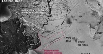
Three weeks after the collapse of the Wilkins Ice Shelf bridge, which connected mainland Antarctica to Charcot Island, satellite pictures reveal that icebergs have begun to calve from the large stretch of ice, indicating that the entire ensemble has become unstable and could soon collapse into the water. The northern front of the ice sheet is most affected, as readings indicate that a large number of icebergs have started floating away from it. This is a direct result of the fact that the bridge connecting the two sections of the shelf gave way at its narrowest portion, which was less than 500 meters wide, on Saturday, April 4th.
“The retreat of Wilkins Ice Shelf is the latest and the largest of its kind. Eight separate ice shelves along the Antarctic Peninsula have shown signs of retreat over the last few decades. There is little doubt that these changes are the result of atmospheric warming on the Antarctic Peninsula, which has been the most rapid in the Southern Hemisphere,” British Antarctic Survey (BAS) expert David Vaughan explained.
He went on to say that, “The changes to Wilkins Ice Shelf provide a fabulous natural laboratory that will allow us to understand how ice shelves respond to climate change and what the future will hold for the rest of Antarctica. The quality and frequency of images acquired by ESA satellites mean that the break-up of Wilkins Ice Shelf can be analyzed far more effectively than any previous event. For the first time, I think, we can really begin to see the processes that have brought about the demise of the ice shelf.”
“We are not sure if a new stable ice front will now form between Latady Island, Petrie Ice Rises and Dorsey Island. If the connection to Latady Island is lost, the projected loss of 3370 sq km of ice might be greater – though we have no indication that this will happen in the near future,” Institute of Geophysics researcher Dr. Angelika Humbert warned, and added that experts were unsure at the moment as to how the massive ice shelf would act, given the drastic influences it was being subjected to.
The new study and estimates have been made possible by combining images from TerraSAR-X's high-resolution camera with ordinary Envisat pictures, which usually keep the Antarctic under constant surveillance. With these two observatories in the sky, the European Space Agency (ESA) hopes to be able to provide Antarctic researchers with all the data they need to understand exactly how the ice shelves handle under increasing temperatures.

 14 DAY TRIAL //