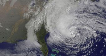
A team of University of Utah researchers speaking at the April 18 annual meeting of the Seismological Society of America argued that, when Superstorm Sandy hit the United States back in last year's October, it did more than wreak havoc on the country's East Coast.
Long story short, these researchers maintain that the storm triggered seismic waves that were felt all across the country.
As they explain, these movements in the Earth's crust were caused by the powerful waves that kept smashing both into the country's eastern coastline and into each other.
The researchers say that, for the most part, the shaking has to be attributed to the fact that waves kept colliding with one another in the ocean, thus causing movement in the seafloor.
EurekAlert quotes Keith Koper, a seismologist and a professor of geology and geophysics, who wished to make the following observations:
“They are not earthquakes; they are seismic waves. Seismic waves can be created by a range of causes. We have beautiful seismic records of the meteor that hit Russia. That's not an earthquake, but it created ground motion.”
When measured on the earthquake magnitude scale, the seismic waves caused by Sandy were found to have been the equivalent of a 2-3M quake as far as the energy generated by them was concerned.
Due to the fact that, unlike an earthquake, the storm shook the ground for several hours in a row, the researchers explain that the seismic waves felt nothing like a 2-3M quake.
The same source informs us that the seismic waves caused by this storm were detected by seismometers across the country. Thus, they were felt even as far as Seattle.
Earthscope, a National Science Foundation, plans to use these seismic waves to piece together images of both the Earth's crust and the upper mantle found beneath North America.
“The energy generated by Sandy is going to be used to image the crust and upper mantle under North America. We are using seismic waves created by ocean waves to make images of the continent,” Keith Koper explained.

 14 DAY TRIAL //