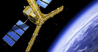
The European Space Agency's (ESA) Soil Moisture and Ocean Salinity Satellite (SMOS), a part of the Living Planet Program, has recently finished activating its MIRAS instrument, the primary science payload. The agency made the announcement recently, highlighting the fact that the instrument would play an essential part in understanding the role that soil moisture and ocean salinity played in regulating the planet's water cycle.
“Following the switch-on, MIRAS is working beautifully well with all key subsystems, including all of the receivers, the optical fibers and the correlator unit, in perfect functioning condition. We have been able to produce reasonable test data even without in-orbit calibration,” the SMOS Instrument Principal Engineer, ESA expert Manuel Martin-Neira, says. The Microwave Imaging Radiometer using Aperture Synthesis is an L-band radiometer, featuring 69 receivers mounted on three deployed arms.
The satellite also features a large number of heaters on its three arms, primarily because all of the sensors mounted on these structures need to operate at very close temperature intervals. According to the spacecraft's technical specifications, it operates best at 22 degrees Celsius, with a difference of +/-3 degrees Celsius between each of the individual sensors. The recent activation of MIRAS was not of concern to mission controllers because of these ensembles, but on account of the fact that the central, onboard computer needed to be booted.
“The active thermal control is now in operation and is keeping the instrument well within the expected temperature range. Tomorrow we expect to assess the payload at the final 22°C temperature,” Mr. Martin-Neira adds. “With the critical launch and early orbit phase completed, the engineers can now evaluate the quality of the downlinks and concentrate on the calibration of the instrument,” SMOS Project Manager Achim Hahne says.
The main goal of SMOS' mission is to analyze the faint radio waves that are emitted through the top layer of the soil and sea water. According to hydrologists, the strength of these signals can be used as a clear indicator of how much water there is in the ground, information that, in turn, could be used to anticipate floods earlier than currently possible, and also to improve weather forecasts. In spite of the fact that it will do this roughly, SMOS will be the first satellite of this type to perform a global measurement of these readings, ESA officials say.

 14 DAY TRIAL //