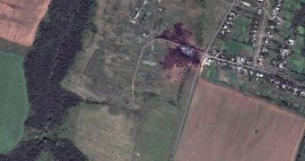
Last week, Malaysia Airlines flight MH17 crashed in eastern Ukraine, not too far from the country's border with Russia. Days later, on July 20-21, a Colorado-based company identified as DigitalGlobe snapped photos of the crash site as seen from space.
One of these photos is available above, and it shows the main debris field smack at the center of a blackened patch of land. Slightly smaller bits and pieces of the MH17 aircraft are visible close nearby, lying on local farmland.
As one can easily notice, Malaysia Airlines flight MH17 crashed dangerously close to a human community. According to Live Science, this community is the village of Hrabove in Ukraine's conflict-ridden Donetsk region.
It is believed that Malaysia Airlines flight MH17 ended up lying on the ground in Ukraine after being shot by a missile. The incident occurred on Thursday, July 17. All in all, 298 people lost their lives at the time when the plane crashed.
Media reports say that, of the people who lost their lives in this plane crash, several dozens were HIV/AIDS researchers who were on their way to a conference in Australia. Besides, three of the victims were mere infants.
At the time when the plane got hit while flying over Ukraine and crashed, the aircraft was traveling from Amsterdam to Malaysia. Investigations into this incident are still ongoing.

 14 DAY TRIAL //