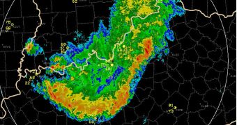
According to weather experts, a windstorm that blew in the United States in May 2009 was so intense and devastating that it laid the foundations of a new class of storms, which is no called super-derecho.
The event affected no less than three states, sweeping through Illinois, Missouri and Kansas. It was a very powerful derecho, which is Spanish for “straight.”
This type of events occurs when windstorms form in very straight lines, rather than in the swirls of a tornado. The formation usually develops in a line of severe thunderstorms called a bow echo.
It's not often that areas of the US observe derechos. It is estimates that, around the country, there are one to three such events each year. For comparison, experts expect to see 8 to 12 hurricanes this season, which may develop into tornadoes.
The first event that was termed derecho occurred more than a century ago, and the name stuck to this day. However, until the May 8, 2009 one, the formations have been relatively harmless.
But the recent derecho was extremely intense, featuring a large vortex at the middle of an eye-like structure. This is the same type of manifestations that occurs at the center of tropical storms.
The storm boasted winds of 70 to 90 miles per hour (115 to 145 kilometers per hour), and spun off more than 18 tornadoes as it tracked across Kansas.
As it gathered force in the early hours of the morning, its devastating power increased considerably, reveals study team member Clark Evans, LiveScience reports.
He is based at the National Center for Atmospheric Research (NCAR), in Boulder, Colorado. The facility is sponsored and otherwise supported by the US National Science Foundation (NSF).
The expert reveals that, when the storm passed over the Mississippi River, it had a speed of 90 to 100 mph (145 to 160 kph). The derecho eventually died out over the eastern borders of Illinois.
Even before the storm developed, researchers were able to model it on their computers with extreme accuracy, and now that data is being used to understand precisely how and why the event was so intense in nature.
“We are currently in the process of determining how the super derecho developed and evolved, seeking to understand how and why it became so strong as compared to other derecho events,” Evans explains.
“We also want to know how and why the eye-like structure and associated intense area of low pressure developed, especially given the exceedingly rare nature of these features,” he concludes.

 14 DAY TRIAL //