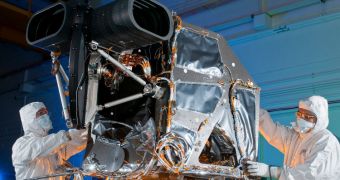
Officials at the NASA Goddard Space Flight Center (GSFC), in Greenbelt, Maryland, recently approved the transfer of the Operational Land Imager (OLI) instrument to a facility where it can be integrated to its carried spacecraft, the Landsat Data Continuity Mission (LDCM).
The satellite is currently being put together by engineers at the Gilbert, Arizona-based Orbital Sciences Corporation (OSC). OLI was designed and built at Ball Aerospace & Technologies Corporation, in Boulder, Colorado, where it was recently completed.
The GSFC manages the mission for the American space agency, so its consent was absolutely necessary in order for the instrument to be moved. Once it arrives in Arizona, the sensor will be integrated on the LDCM satellite platform.
This spacecraft is part of the Landsat program that NASA and the US Geological Survey (USGS) have been managing jointly for more than 40 years. The LDCM represents the follow up to the Landsat 5 (1984) and Landsat 7 (1999) missions.
“OLI will be more sensitive to land cover changes and characteristics across the landscape and over time than previous Landsat instruments,” GSFC LDCM project scientist James Irons explains.
“Analysts will be better able to identify and characterize land cover while also being better able to detect and monitor change,” the investigator goes on to say. He believes that this new spacecraft, which is currently scheduled to launch in late 2012, represents an excellent continuation for Landsat.
The goal of the entire program is to collect countless images of our planet. The data obtained in this matter is then centralized in historical archive featuring information of exquisite quality and detail.
Thus far, the Landsat program has found applications in the fields of agriculture, geology, forestry, regional planning, education, mapping and global change research, experts say. For decades, these datasets have remained a landmark for scientists.
The goal of the LDCM is to ensure that this legacy is kept intact. Experts say that this will be achieved with the help of OLI and the Thermal Infrared Sensor (TIRS), the second instrument on the satellite.
“OLI provides the key sensor technology to allow continuation of Landsat Earth observations into a fourth decade. This continuation is essential to maintain seamless acquisition of Earth-from-space images not captured by any other private or public source,” Ball Aerospace CEO David L. Taylor says.
After engineers at OSC finish integrating the two scientific instruments with their spacecraft platform, the entire LDCM will be sent to the Vandenberg Air Force Base (VAFB), in California. NASA and USGS decided to use this launch facility for the mission, in December 2012.

 14 DAY TRIAL //