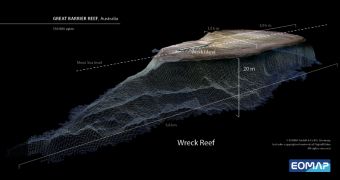
Experts at the German aquatic remote sensing company EOMAP have recently used a satellite in Earth's orbit to create a high-resolution, 3D map of the Great Barrier Reef, the single most important coral reef ecosystem in the world. The dataset will be used to inform future conservation efforts.
This formation is actually made up of around 2,900 individual, smaller reefs, and comprises a total of 900 islands. The Great Barrier Reef is located off the coast of Australia, in the Coral Sea, and is around 2,600 kilometers (1,600 miles) long. It covers an area of around 344,400 square kilometers, or 133,000 square miles.
The new study was conducted so that researchers could accurately identify all the submerged reef formations. This will enable them to develop means of managing and protecting this incredible hot spot for biodiversity in the years to come, as encroaching human influences damage it more and more.
In addition to global warming and climate change, other factors that threaten the Great Barrier Reef include pollution, overfishing, starfish outbreaks and oceanic acidification. Scientists are currently monitoring it for signs of coral bleaching, a tell-tale sign that the reef is decaying.
The new investigation was able to produce a 3D map of the entire reef by using DigitalGlobe’s Worldview-2 satellite. The spacecraft was launched into space on October 8, 2009, aboard a Delta II rocket that took off from the Vandenberg Air Force Base (VAFB), in California.
According to experts at EOMAP, satellites such as Worldview-2 provide the best way to analyze such vast reefs, because airplanes and research boats cannot efficiently cover such huge distances.
The group developed the new 3D visualizations by combining satellite data with existing ocean floor topography data and additional information on tides. EOMAP plans to use the European Space Agency's (ESA) upcoming Sentinel-2 mission to analyze ocean floor topography in even more detail.
“All of the mapped areas, at a resolution of 30 m (98.5 feet) are available for purchase through the company’s website. A coarser product with 500 m (1640-foot) resolution is also available free of charge, together with sample data of the high-resolution products,” ESA officials say in a statement.

 14 DAY TRIAL //