It's not easy to compete with Google, but Yahoo! seems to be up for the job or at least right now it is. The new releases seem to top each other's and right now it's the Sunnyvale, California based company's time to shine.
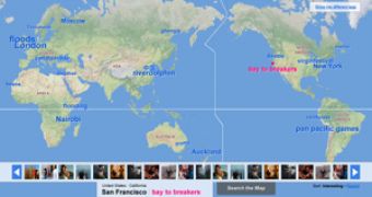
Flickr, Yahoo's popular photo sharing site, has released today two new geography-related features that have been awaited by its fans with the utmost anxiousness: Flickr Places and a new world map.
The first is the one that thrills me the most because the developing team have chosen over 100,000 locations across the globe, like cities, states, countries and regions and created pages with the specific purpose of displaying pictures taken at them. It's going to be something like a compilation of information about that specific place you are searching for, with all sorts of pictures taken by users, maps, weather and current times and more categories are expected to be added in the future.
The second feature, the world map, will be bringing new to the table a lot of user interface improvements and "hot tags" that will appear instead of the simple pink dots of the past version. A "photo ribbon" made out of photos taken at the place of your interest will appear whenever a user clicks on one of the hot tags. The means to link photos to the map appears to be the traditional geo-tagging methods, user defined, although Yahoo! has announced its FireEagle that might help a lot regarding this aspect. Whichever it's going to be is irrelevant at the moment, as the feedback will start pouring in it's a sure thing that things will change for the better if something's not there yet.
The new update is available in eight languages, following Yahoo!'s tendency to release its products in as many languages as possible in order to draw more and more users on it's sites. And with Flickr hosting over two billion photos (the mark was reached last week) it looks like they're doing a good job.

 14 DAY TRIAL //