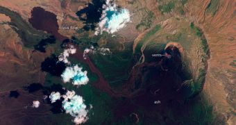
At the border between Eritrea and Ethiopia, in Africa, the Nabro Volcano has apparently been operating since June 2011. Satellite imagery recently confirmed that the mountain is still active, spreading lava and large ash clouds above large areas
The edge of the Danakil Desert is very remote and only sparsely populated, which may help explain the lack of reports on the condition of the volcano. A recent pass by the NASA Earth Observing-1 (EO-1) finally revealed that activity levels have not subsided.
EO-1 features remarkable capabilities for imaging these types of natural disasters, such as the Advanced Land Imager (ALI) instrument. According to experts, these are the only currently available methods of knowing what's going in the Danakil Desert.
This false-color image of the mountain was acquired on September 28. Areas marked by red circles indicate locations where heat is coming out of vents alongside the volcano. An active lava flow can be seen about 1,300 meters (4,600 feet) away, to the left of the image.

 14 DAY TRIAL //