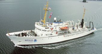
Remote areas of the Arctic will receive the visit of the research ship the Fairweather, which experts at the US National Oceanic and Atmospheric Administration (NOAA) are now using to conduct hydrographic surveys in unstudied regions.
The Arctic areas where the Fairweather will be conducting its investigation have never been surveyed since the United States bought Alaska from Russia, back in 1867. NOAA plans to right this wrong.
Its 231-foot survey vessel left the port of Kodiak, Alaska on Thursday, July 7, to begin a long journey that will take it through little-traveled areas. The main goal of the new research effort is to update nautical charts that help make navigation in these waters safer.
According to officials at the federal agency, these waters are extremely important for the economy and security of the United States, and yet they are extremely sparsely charted. Now that global warming is melting the Arctic ice sheets, these waters may be used as new shipping lanes.
Climate change is leading to progressive, accelerated ice loss in the Arctic region. As ices retreat, more and more regions become suitable for navigation. It is estimated that, in 30 to 40 years, the North Pole will be losing all of its ices during the summer months.
This opens up the prospect of new shipping opportunities on these once-off-limits waters. Increasing vessel traffic can already be seen in the area, but the nautical charts the ships use are dated and old.
Fairweather is now headed for northwestern Alaska, in the Arctic Circle, where it will chart about 402 square nautical miles of important waters in Kotzebue Sound. Experts estimate that the effort will last about two months.
“The reduction in Arctic ice coverage is leading over time to a growth of vessel traffic in the Arctic, and this growth is driving an increase in maritime concerns,” NOAA Corps Capt. David Neander says.
“Starting in 2010, we began surveying in critical Arctic areas where marine transportation dynamics are changing rapidly. These areas are increasingly transited by the offshore oil and gas industry, cruise liners, military craft, tugs and barges and fishing vessels,” he adds.
Neander, the commanding officer of the Fairweather, says that the ship itself will only survey deep waters, while several survey launchers will be used to chart out the more shallow regions. The data will cover ocean depth, 3D images of the seafloor, and the detection of underwater hazards.
“NOAA’s Arctic surveys and charting plan identify the additional hydrographic coverage necessary to support a robust maritime transportation infrastructure in the coastal areas north of the Aleutian Islands,” adds NOAA Corps Capt. Doug Baird.
“With the resources we have available, we are building the foundation to meet the burgeoning demands of ocean activities around Alaska’s waterways,” adds the official, who is the chief of the NOAA Marine Chart Division in the Office of Coast Survey.

 14 DAY TRIAL //