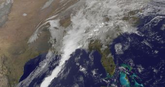
The Geostationary Operational Environmental Satellite N (GOES-13), operated by the US National Oceanic and Atmospheric Administration (NOAA) observed this massive cold front heading towards the United States on Thursday, January 26.
The massive cloud was bound to cause severe weather, and will most likely continue to do so for at least a few more days. The southeastern parts of the country are expected to suffer the worst consequences. The clouds seen from orbit are caused by a very strong cold front.
According to climate experts, this is the same cold front that struck Texas on January 25, causing flooding, tornadoes and heavy rainfall across the state. At some locations, wind speeds exceeded 50 miles (80.5 kilometers) per hour.
States that were affected by the cold front yesterday – and will continue to be so for the near future as well – include Louisiana, Mississippi, Alabama, Georgia and the Florida panhandle. Tornadoes may occur in all these regions.
Some of these areas experienced wind speeds of up to 60 miles (96.5 kilometers) per hour, heavy rainfall, small hail, extreme lightning and several small tornadoes. Thunderstorms warnings were in effect throughout yesterday morning.
NOAA experts say that the GOES-13 satellite will continue to monitor the eastern and southern sectors of the United States, from its geostationary operational orbit, at longitude 75° West. The spacecraft was launched specifically to cover weather forecasts for this portion of the country.
The other half of the country, and adjacent portions of the Pacific Ocean, are monitored by the GOES-15 satellite. Both spacecraft can also track space weather, oceanographic changes, forest fires and other natural hazards.
GOES-13 is operated by NOAA and NASA, and is scheduled to ensure weather data for 10 years. It was constructed by The Boeing Company, and was launched aboard a Delta IV rocket on May 24, 2006, from Space Launch Complex-37B at the Cape Canaveral Air Force Station (CCAFS), in Florida.

 14 DAY TRIAL //