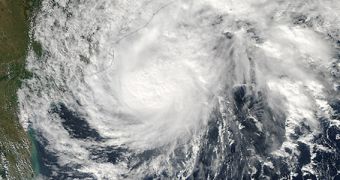
Following the passage of Supertyphoon Haiyan, people living in the Indian ocean are understandably worried about each cyclone or tropical storm that forms in the region. This is why NASA used one of its spacecraft in low-Earth orbit to image the latest atmospheric phenomenon, called Cyclone 04B.
The storm, nicknamed Helen, was photographed by the NASA Aqua satellite on November 21, 2013. The detailed image was collected with the Moderate Resolution Imaging Spectroradiometer (MODIS) instrument, which has been used for such applications numerous times.
The storm has since made landfall in the Andhra Pradesh province, India, after moving further northeast from the position illustrated here. However, its winds decreased in speed considerably when the storm's center neared land, and Helen is now just a Category 1 cyclone.
Regardless, Indian authorities have already prepared evacuation procedures for several coastal areas. Yesterday, Cyclone 04B produced wave heights of 6 meters (20 feet) in the open ocean, and wind speeds reaching sustained levels of 102 kilometers (63 miles) per hour.

 14 DAY TRIAL //