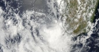
The image above, snapped via the Moderate Resolution Imaging Spectroradiometer (MODIS) instrument on the NASA Aqua satellite, focuses on a tropical depression now called Deliwe, which forms over waters southwest of Madagascar.
The photo was collected on January 16, and shows the moment where Deliwe turns from a tropical depression (called 09S) to a tropical cyclone. Aqua made another pass over the formation on January 17, when additional MODIS data confirmed that it was now a cyclone.
Scientists with the Joint Typhoon Warning Center announced that Deliwe is now a very well-defined center of atmospheric circulation, meaning that it has a lot of potential to grow into an ever more severe storm over the past few days. It is currently heading south in the southern Indian Ocean.
On Friday, the storm boasted maximum sustained wind speeds of 83 kilometers (52 miles) per hour, and was centered 694.5 kilometers (431.5 miles) southwest of Antananarivo, Madagascar. Climate experts say that the storm could dissipate in about 4 days.

 14 DAY TRIAL //