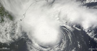
The Moderate Resolution Imaging Spectroradiometer (MODIS) instrument on the American space agency's Terra satellite has just imaged the tropical storm Alberto, which is currently over the Atlantic Ocean. This photo was collected on Saturday, May 19.
Experts at the US National Hurricane Center (NHC) were the first to report that Alberto had formed off the coasts of South Carolina. NASA responded quickly, and had Terra make a pass over the area the very same day.
Alberto is unlikely to pose a serious threat. The MODIS image reveals that it has no central eye, and ground readings indicate that its top wind speeds did not exceed 95 kilometers (60 miles) per hour.
Climatologists say that this is the first tropical storm to develop in the 2012 hurricane season, which officially begins on June 1. The NHC continuously keeps track of weather fronts heading for the United States from the Atlantic.

 14 DAY TRIAL //