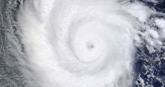
Using the NASA Terra satellite and its Moderate Resolution Imaging Spectroradiometer (MODIS) instrument, experts from the American space agency snapped a new image of Hurricane Emilia yesterday, July 9.
Currently flying over the eastern Pacific Ocean, the tropical storm was cataloged as a Category 2 hurricane by the US National Hurricane Center (NHC) on Monday. The warning entered into effect at 2:00 pm PDT (1900 GMT).
NHC officials warned yesterday that the tropical storm features maximum sustained winds of 110 miles (175 kilometers) per hour. Today, July 10, just 12 hours after the original announcement, Emilia's classification was increased to a Category 4 hurricane.
At this time, the storm boasts winds of up to 140 miles (220 kilometers) per hour. The image above shows the storm as it appeared yesterday, when it was located some 680 miles (1,095 kilometers) off the coasts of Baja California.

 14 DAY TRIAL //