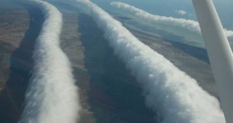
The Northern Australian Gulf of Carpentaria is every year the host of one of the most remarkable and strange atmospheric phenomena in the world. Dubbed the Morning Glory, it consists of rows of tubular clouds, which can span more than 1,000 kilometers in length. Although a beauty to behold, they cause problems for airplanes flying in the area even over windless days. Scientists have been studying them for a long time, but, until now, they have only found out that the peculiar formations are a form of roll clouds and nothing more.
Theories on how the Morning Glory forms abound, but some of them have no contact with reality to speak of. Others make a little more sense, although the international scientific community has yet to reach any consensus on the issue. It can be best observed in autumn, in the skies over and around the town of Burketown, Queensland (population 200). Some of these formations can grow to a height of one to two kilometers, and can travel as fast as 35 miles per hour. As it moves over the land, the phenomenon causes a lot of disturbances in the regular flow of air, Wired reports.
For instance, it generates sudden wind squalls, and intense low-level wind shears, as it rolls past. According to some measurements, a sharp pressure jump is also recorded at the surface, inconclusive with other readings collected from places around the world where usual roll clouds appear. Meteorologists also say that air parcels become vertically displaced and mingled, a situation that is very dangerous for incoming aircraft. In spite of this fact, every year, gliders and small airplanes gather in the small town, to “surf the clouds.”
Inhabitants of Burketown say that the Morning Glory is more likely to form when more humidity is recorded in the air, and also when strong breezes blow the day before. The appearances are usually associated, climatologists say, with frontal air systems crossing central Australia, which collide with high pressures that form in northern Australia. Other experts believe that the phenomenon may appear on account of the interactions of mesoscale circulations, associated with sea breezes that develop over the peninsula and the gulf.

 14 DAY TRIAL //