While most of the United States and Canada were struggling to deal with the cold snap the polar vortex produced in early January, mountain ranges in California and elsewhere are faced with the real prospect of not being able to accumulate sufficient ices to replenish rivers throughout this year.
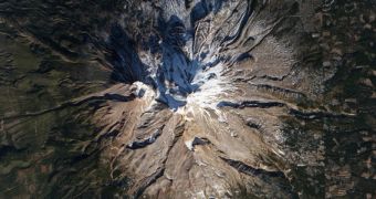
In this image of Mount Shasta, the small ice extent on its peaks is clearly visible. In previous years, ice packs extended all the way down to the base of the mountain on all sides, but not so on January 4, when the photo was captured. Rivers downstream from the mountain are not too likely to receive sufficient amounts of meltwater in the spring.
The photo above was collected on January 4, 2014, by the Operational Land Imager (OLI) instrument on the NASA/USGS Landsat 8 satellite. The image was then compared to a similar view, captured by the same spacecraft on November 1, 2013. The analysis revealed that three of the mountain's four slopes lost ice during the winter, instead of replenishing.
Due to lack of snow, skiing was nearly impossible on the mountain. According to the Mount Shasta Avalanche Center, the danger of avalanches for areas except the tallest peaks is non-existent. The absence of snow is very bad news for people who rely on nearby rivers for drinkable water.

 14 DAY TRIAL //