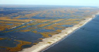
A group of researchers has recently determined that the Mississippi River delta may in fact be playing a beneficial role in protecting the delicate Louisiana coastlines from the effects of crude oil contamination. With the explosion of the Deepwater Horizon drilling rig, about two months ago, the delicate ecosystems that cover Louisiana's coastlines, and provide spawning grounds for several species, have come under considerable danger from oil slicks, tar balls, and other such formations.
The new investigation was carried out on Louisiana's Wax Lake Delta, by a team of investigators from the University of Minnesota-based National Center for Earth-surface Dynamics (NCED). This is a Science and Technology Center of the US National Science Foundation (NSF). The group here has been conducting a series of measurements on the coastal Louisiana wetlands, including assessments of the baseline conditions, and tracking the effects of crude oil contamination at these locations.
“Since the Mississippi River is currently at a relatively high stage, we expect the river's high volume of freshwater to act as a hydrologic barrier, keeping oil from moving into the Wax Lake Delta from the sea,” explains Robert Twilley, who is a research scientist at the Louisiana State University (LSU). “The Mississippi River's 'plumbing' provides a potential benefit to reducing the movement of oil onshore from shelf waters,” he adds. Together with LSU colleague Guerry Holm, the scientist looked at plants and soils in the region, in a bid to determine the extent of the potential damage they suffered from oil contamination. Freshwater and saltwater in Louisiana wetlands were also analyzed, the team says.
Louisiana wetlands “play a vital role in protecting New Orleans from hurricane damage, providing habitat for wildlife, supporting economically important fisheries, and maintaining water quality. We must look at all options for protecting them for the future,” states the director of NCED, Efi Foufoula-Georgiou. Speaking of the challenges ahead in protecting Louisiana;s shorelines, Lane adds: “As the river stage falls and protection diminishes, it becomes a question of how best to distribute this freshwater resource to defend the coast from the movement of oil onshore.”
The Deepwater Horizon semi-submersible drilling rig, which operated only tens of miles south of the coasts of Louisiana, suffered a large explosion on April 20. Eleven crew members are assumed dead, and all rescue efforts aimed at finding them have long since been called off. On April 22, the rig sunk into the waters of the Gulf, in spite of the fact that emergency response ships were on-site, evacuating workers, and pouring water on the platform. With the collapse of the Horizon, the pipes that carried the oil from a depth of 5,000 feet (1,500 meters) broke.
The valves designed to stop the oil flow in such an instance malfunctioned, and thousands of barrels of crude oil have been spilling in the water daily ever since. The actual amount may be a lot larger than this, experts warn, which means that the damage may be considerably larger than initially estimated. Given the size of the slick, some hypothesize the oil may have moved from the site in underwater plumes, which are extremely difficult to detect, even with sensitive Earth-observing satellites.
“As part of the federal government's ongoing response to the BP spill, the Environmental Protection Agency (EPA) continues its extensive air quality monitoring along the Gulf Coast. In this case, NOAA and EPA are working collaboratively to take advantage of NOAA’s highly specialized atmospheric research capabilities, which can detect concentrations of compounds in the atmosphere with greater sensitivity than standard operational monitoring flights. The P-3 is currently involved in a major climate and air quality study in California, called Calnex, which is why it is already properly outfitted for this emergency gulf mission. Another NOAA P-3 is also in the Gulf and has done multiple flights to help monitor the location of the Loop Current,” NOAA officials recently said in a statement.

 14 DAY TRIAL //