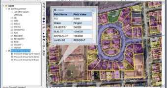
Microsoft Virtual Earth is continuously expanding; the territories added to the service are not limited to new data and imagery, but also to the expansion on third party applications and services. Case in point: the partnership inked by Microsoft with ESRI, making Virtual Earth a component of the ESRI's ArcGIS Online Services. S.J. Camarata, Director of Corporate Strategies at ESRI, applauded the bridging of the ArcGIS Desktop and ArcGIS Server with Virtual Earth as a chance for end users to get access to the robust mapping and imagery content offered by the Redmond company.
"Microsoft and ESRI have a long-standing history of delivering complete geographic information systems solutions," stated Erik Jorgenson, corporate vice president at Microsoft. As a direct result of the new partnership, the ArcGIS 9.3 Desktop will deliver Virtual Earth integrated by default. Microsoft informed that users of the ArcGIS 9.3 Desktop will be able to add and publish aerial and hybrid maps, as well as to author, edit and analyze adjacent data.
"The integration of Virtual Earth and ArcGIS 9.3 at both desktop application and platform levels enables customers to better view, analyze, understand, interpret and visualize geographic data. This new offering further extends the software-plus-services choices available to our mutual customers," Jorgenson added.
Camarata revealed that ArcGIS 9.3 Desktop would have hybrid and street maps as well as vertical imagery available through the client straight from Virtual Earth via an annual subscription fee. The Redmond company informed that, in the future, a service pack release would permit access to the ArcGIS Online Virtual Earth Map Services from the ArcGIS Server.
"As a part of the version 9.3 release, Virtual Earth will natively be a premium content layer so you can simply select to view your data on our roads, high resolution aerial photography and Bird's Eye imagery. This is different from the 'ESRI ArcGIS JavaScript Extension for Virtual Earth' because that is working directly with the JavaScript controls. The big news today is that right in ESRI ArcGIS Desktop 9.3 you will have Virtual Earth maps to better visualize your data," informed Chris Pendleton, Virtual Earth Technical Evangelist.

 14 DAY TRIAL //