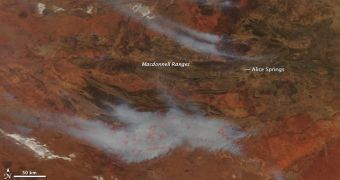
A large area of land near Alice Springs, Australia, is currently plagued by large wildfires, which are moving through the landscape devouring everything in their path. A NASA satellite was recently able to image the natural disaster, assisting authorities in figuring out a way to handle the fires.
According to data supplied by the Moderate Resolution Imaging Spectroradiometer (MODIS) instrument on the NASA Aqua satellite, it would appear that entire roads and railways have been covered by smoke, preventing traffic and causing important economic losses.
In this image, which was captured yesterday, September 29, the outlines of the actual fires are drawn in red. The thick smoke clouds themselves are spreading for hundreds of kilometers north and south from their point of origin, threatening other areas as well.
According to reports in the Sydney Morning Herald newspaper, the incidence of wildfires has been very high throughout September because the country has been drenched in water earlier this year. Rains lead to the formation of grasses throughout the continent, which are now dry and flammable.

 14 DAY TRIAL //