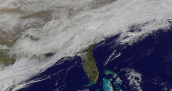
On March 3, a large snowstorm plowed through the mid-Atlantic and East Coast regions of the United States, accompanied by the massive clouds you can see above. The image was collected from orbit by the US National Oceanic and Atmospheric Administration's (NOAA) Geostationary Operational Environmental Satellite (GOES) 13, or East, satellite.
The photo reflects how the winter storm brought a lot of snow to mid-Atlantic regions, while battering both Carolinas with freezing rain. Most Gulf Coast states were battered by either regular or freezing rain. Snow covered important areas in Washington, DC, Delaware, central Virginia, West Virginia, and eastern Kentucky.
In all likelihood, the snowstorm will continue to drift eastward through the Tennessee Valley and the mid-Atlantic today, March 4, announce officials with the NOAA National Weather Prediction Center in College Park, Maryland. Storm warnings issued by the National Weather Service have been in effect in the Washington DC area until 6 pm local time (23 GMT) on March 3.
According to the NWPC, it is very likely that temperatures colder than usual will continue to affect areas east of the Rocky Mountains throughout early March. NOAA and NASA space assets will continue to monitor the situation, and provide timely information for federal and local emergency agencies.

 14 DAY TRIAL //