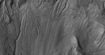
In a new image made available by scientists at the NASA Jet Propulsion Laboratory (JPL), in Pasadena, California, traces of active processes inside Martian craters can be clearly seen. The variety and complexity of these past events puzzle astronomers, which are not forced to revise existing knowledge of how the past of the Red Planet must have looked like. The group that analyzed the new photos says that the processes which left their scars on the crater walls occurred much later after the craters themselves were formed, most likely due to asteroid impacts.
The picture was snapped using the High Resolution Imaging Science Experiment (HiRISE) camera, aboard the NASA Mars Reconnaissance Orbiter (MRO). The spacecraft has been orbiting Mars for a long time and is mainly responsible for some of the largest advancements we made in our understanding of how our neighboring planet evolved. The orbiter is currently in a minimally-functioning state, known as the “safe mode,” as experts at JPL attempt to find ways of restoring its full scientific capacities. It suffered four computer glitches this year, of which one forced it to switch between its two computer systems, and mission controllers want to know the cause of the problem before allowing it to resume operations again.
“Reaching down the walls of the crater are winding and crooked troughs, or gullies. Some of these gullies may have formed with the help of liquid water, melted from ice or snowpack on the crater walls or from groundwater within the walls. Also notable is the long tongue-like lobe stretching down the middle of the image, with a darker, rounded snout and prominent parallel grooves on its surface. These characteristics, together with faint cracks on its surface, suggest that this lobe may have formed by movement of ice-rich material from up on the crater wall down to the crater floor,” says a statement on the official JPL news blog.
The HiRISE observations were carried out on July 1, 2009, before the August 26 glitch, that forced the MRO to reboot its computer again. The surface area that the photograph covers is 6 kilometers, or 4 miles, wide, and is located at 32.4 degrees south latitude and 103.2 degrees east longitude. The experts also determined that the move of the ice-rich materials, or perhaps even of liquid water, did not occur very recently, such as for instance in the last billion years. A long time ago, the Red Planet was a place that could have sustained life, possibly with a large ocean in the northern hemisphere, glaciers and liquid water flowing at several locations, according to other MRO images. However, since the planet tilted its orbit in regards to the Sun, it lost all these features.

 14 DAY TRIAL //