The surface of Mars is largely recognized by three things, namely that it's reddish, has a lot of sand storms ravaging it, and features a multitude of craters, each of them of varied ages and depths. The rover Spirit, for example, is currently stuck inside one of these craters, while its twin, Opportunity, is, at this point, heading for one, having already investigated another a couple of years back. From above, the NASA Mars Reconnaissance Orbiter (MRO) and Mars Odyssey spacecraft are also snapping photos of the crater features non-stop, which allows researchers to construct new models based on the data.
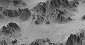
The latest model that NASA experts developed focuses on the famous Mojave Crater. The data used to create the new model were collected by the MRO, via its amazing High Resolution Imaging Science Experiment (HiRISE) camera. This particular instrument has captured over the years most of the breathtaking vistas on Mars, including landslides, craters, hills, volcanoes, canyons and sand dunes. During its observations of this particular crater, it has focused on collecting data on it from various angles, so as to allow researchers to create a model as seen from an angle not possible from the orbit.
Researchers managed to do just that. They centralized all HiRISE data, and then combined them in this new image. They then exaggerated the vertical dimension of the crater wall three-fold, when compared with the horizontal dimension, as this is a synthesized image of a portion of the Mojave Crater's wall. The end-result is a photograph that looks as if it was snapped by an airplane flying at a low altitude over the landscape feature. Collecting such photos directly is obviously not possible from orbit, experts at the NASA Jet Propulsion Laboratory (JPL), in Pasadena, California, say.
“This enhanced view shows material that has ponded and is backed up behind massive blocks of bedrock in the crater's terrace walls. Hundreds of Martian impact craters have similar ponding with pitted surfaces. Scientists believe these 'pitted ponds' are created when material melted by the crater-causing impacts is captured behind the wall terraces,” JPL experts write in a press release on their official website.
“Mojave Crater, one of the freshest large craters on Mars, is about 60 kilometers (37 miles) in diameter. In a sense, it is like the Rosetta Stone of Martian craters, because it is so fresh. Other craters of this size generally have already been affected by erosion, sediment and other geologic process[es]. Fresh craters like Mojave reveal information about the impact process, including ejecta, melting and deposits,” they add.

 14 DAY TRIAL //