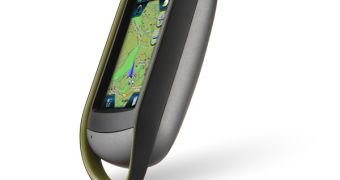
Magellan's eXplorist line of rugged GPS navigators is quite well known for the very good level of positioning efficiency, as well as extra features it provides for outdoors adventurers, but it seems that the company's keen on expanding it even further.
For this reason, Magellan has recently unveiled the eXplorist 610 GPS receiver with Summit Series topographic maps of Canada preloaded, designed specifically for mountaineers planning a serious adventure in the Canadian mountains.
The eXplorist 610 offers a large number of features that will sure come in handy, beside of the many preloaded POIs, geocache support (GPX files) and maps.
In fact, the device sports a touch-sensitive display with 4-Corners user interface, that will really prove its worth when navigating forests and ravines, as well as a high-sensitivity GPS receiver, that will work quite well in every circumstance, even in dense foliage, a type of environment most users are likely to encounter during their trips in the great outdoors.
Additional features worth mentioning include the 3.2-megapixel built-in camera module, as well as microphone and speaker, allowing users to record short video clips, take voice notes, etc.
Another interesting detail we'll have to talk about is the fact that the eXplorist 610 is powered by two AA batteries, providing around 16 hours of functioning time, but it also sports a handy suspend mode, that allows users to switch off the navigator, while in the same time the 610 continues GPS tracking.
In this way, users will be able to get a complete record of their trip, including time spent traveling between specific route points, that they can later on download to their computers, for reviewing.
Of course, such an advanced rugged GPS navigator does come at a pretty hefty price point, the eXplorist 610 having a suggested retail price of $479.99.

 14 DAY TRIAL //