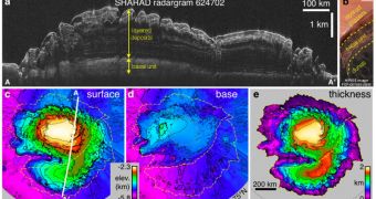
NASA's Mars Reconnaissance Orbiter (MRO) is the most active probe sent to the Red Planet to date. Up until now, it has sent back the most pieces of information on the planet of all missions, and continues to do so at a steady rate, in spite of occasional glitches and reboots. Recently, with the help of one of its advanced instruments, it imaged the layers of ice at the Martian North Pole, and successfully evidenced the fact that geological records were in tune with theoretical-model climate swings during the past few million years, experts at the Jet Propulsion Laboratory, (JPL), in Pasadena, California, report.
According to the measurements, the ice layers stack up neatly on top of each other, and have grown to be two kilometers (1.2 miles) in height. The patterns in which they are arranged offer insight into how they were formed, the JPL team says. Coupled with theoretical models of climate-change cycles on Mars, the new images can lead to a better understanding of how the climate on the planet looked like a few million years ago. The deposits cover an overall area that is roughly one third larger than Texas.
“Contrast in electrical properties between layers is what provides the reflectivity we observe with the radar. The pattern of reflectivity tells us about the pattern of material variations within the layers,” Shallow Radar instrument science team member Nathaniel Putzig, from the Southwest Research Institute, in Boulder, Colorado, explains. More than 358 radar observations were analyzed for the new study, which has been submitted and accepted for publication in the scientific journal Icarus. Details of the investigation are currently available online.
“We're not doing the climate modeling here; we are comparing others' modeling results to what we observe with the radar, and using that comparison to constrain the possible explanations for how the layers form,” Putzig adds. The team reveals that the alternate patterns that were discovered inside the ice layers are also explained by changes in Mars' tilt, over recent times. “The radar has been giving us spectacular results. We have mapped continuous underground layers in three dimensions across a vast area,” JPL expert Jeffrey Plaut, who is a co-author of the journal entry, concludes.
The Italian Space Agency operates the Shallow Radar instrument, which it provided for NASA's Mars Reconnaissance Orbiter. The orbiter has been studying Mars with six advanced instruments since 2006. JPL manages the Mars Reconnaissance Orbiter for NASA's Science Mission Directorate, in Washington DC. Denver-based Lockheed Martin Space Systems is the prime contractor for the project, and also the builder of the spacecraft.

 14 DAY TRIAL //