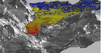
Although it may seem easy to do, measuring the thickness and evolution of glaciers is a very tricky business. Glaciologists still use wooden poles and shovels to measure the thickness of glaciers, or sometimes just shovels. These methods may be very well suited for small applications, such as assessing the yearly or seasonal changes that occur in ice spreads at a certain location, but they leave a lot to be desired when it comes to large-scale observations. Positional measurements cannot be conducted using such primitive methods, and experts therefore find themselves unable to say for certain if a larger glacier is receding or getting thicker, AlphaGalileo reports.
Scientists at the University of Zurich, in Switzerland, are perfectly aware of these limitations, and this is one of the main reasons why they wanted to change this approach. They managed to do so, and are now capable of employing lasers to look for large-scale changes in mountaintop glaciers. “A strongly bundled beam of light is shot from an aircraft and the time is measured that the light needs to reach the surface of the ice and bounce back to the aircraft. From this so-called 'run time,' the distance from the plane to the glacier can be precisely determined to within just a few centimeters,” PhD candidate Philip Jorg, a scientist at the University, explains.
Using these laser data, as well as the precise altitude and position of the aircraft when the measurements are taken, the scientist has developed a method of producing large-scale, accurate, three-dimensional maps of the mountaintops and their glaciers. The new method of doing business was tested this October on the Findel Glacier. A high-resolution laser scanner was used, and the research team made a few flights around the mountain, in order to get all the data they needed. The investigation determined that the glacier lost more than 49 million cubic meters of ice in the last four years alone.
This is equivalent to about 3.5 meters of average ice thickness lost since 2005, when the first such measurements were conducted. The glacier also lost between 25 and 30 meters of ice length from its tongue, the investigators say, which means that the large block of ice is retreating. “While the politicians will be in Copenhagen in the next few days, debating a continuation of the Kyoto Protocol with specific climate targets, we are already working on the basic data of tomorrow,” UZ glaciologist and project leader Mizhael Zemp adds.

 14 DAY TRIAL //